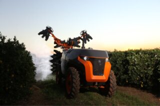
DroneDash Technologies and GEODNET have formed GEODASH Aerosystems, a joint venture developing a new generation of AI-driven spraying drones designed for large-scale industrial agriculture. The platform combines DroneDash’s real-time AI vision with GEODNET’s decentralized RTK GNSS network, enabling centimetre-level positioning without the need for pre-mapped flight plans.
Unlike conventional agricultural drones that rely on manual field mapping and static missions, the GEODASH system operates through real-time perception, dynamically identifying crop rows, canopy structure, and terrain conditions during flight. This eliminates one of the main operational bottlenecks in drone spraying—repeated pre-surveying—while allowing faster deployment and greater adaptability in complex environments such as oil palm plantations and large row-crop systems.
The platform also integrates a backend AI Smart Farming layer, transforming each spraying mission into a data collection process. This enables continuous agronomic insights, including crop health analysis, stress detection, and variable-rate application optimization at tree or zone level.
Target markets include Southeast Asia, the United States, and South America, with commercial rollout expected in Q3 2026 following pilot testing across large-scale operations.
Bottom line
The real signal here is the elimination of pre-mapping as a structural constraint in drone operations.
The implication is clear: autonomy in agriculture is shifting from pre-programmed execution to real-time adaptive intelligence. Platforms that combine perception, positioning, and analytics into a single system will redefine scalability in aerial crop protection.
To dive deeper: https://news.agropages.com/News/NewsDetail—57401.htm